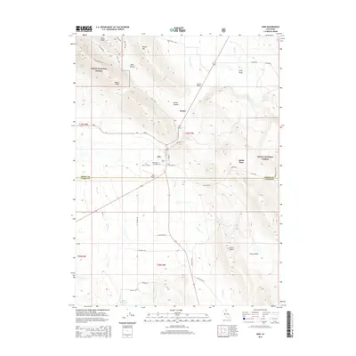
2015 Map of Adin
USGS Topo · Published 2015About this map
The town of Adin serves as a central hub in this high-altitude landscape where the Modoc and Lassen county lines meet. Life in this corner of the Modoc National Forest is defined by its rugged topography, from the heights of Fox Mountain and Brisco Butte to the drainages of Butte Cr and Willow Cr. Genealogists and local historians can find significant landmarks such as the Adin Pioneer Cemetery and the Adin Cemetery, which speak to the long-standing community presence here. The map also captures the agricultural and transit infrastructure of the region, including the Adin Airport and scattered homesteads like Dibble Place. Canyons and ridges like Barber Canyon and Ryan Ridge illustrate a geography shaped by mountain spurs and broad valleys like Ash Valley, showing the intersection of forest service lands and private ranching interests.
Find a feature on this map
44 named features on this map. Tap any name to fly to it.
Don’t see what you’re looking for? This feature index may not catch every label — zoom into the map to look around manually.
Map Details
Editions of this 2015 Adin Map
This is the sole edition of this map. No revisions or reprints were ever made.
Other maps of this area

1886 · Alturas
USGS Topo · 1:250,000

1886 · Modoc Lava Bed
USGS Topo · 1:250,000

1892 · Modoc Lava-Bed
USGS Topo · 1:250,000

1892 · Alturas
USGS Topo · 1:250,000

1954 · Alturas
USGS Topo · 1:250,000

1958 · Alturas
USGS Topo · 1:250,000

1961 · Canby
USGS Topo · 1:62,500

1961 · Bieber
USGS Topo · 1:62,500

1962 · Alturas
USGS Topo · 1:250,000

1962 · Crank Mountain
USGS Topo · 1:62,500