
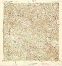
1946 Map of Adjuntas
USGS Topo · Published 1946About this map
Agricultural haciendas define the settlement pattern of this mountainous interior region in the mid-1940s, clustered primarily around the town of Adjuntas. The map documents a traditional landscape where commercial activity centers on sites like Central Pellejas and numerous family estates including Hacienda Tres Hermanas, Hacienda Santa Elena, and Hacienda La Esperanza. The rugged topography is delineated by watercourses such as the Rio Vivi and Rio Grande, which feed into the reservoir at Lago Garzas in the southwest. Spiritual and social life is marked by the Iglesia de la Concepcion Inmaculada and the Iglesia de San Patricio. This survey captures the municipal intersections of Utuado, Jayuya, and Ponce, reflecting an era when mountain agriculture and the hacienda system remained the backbone of the local economy.
Find a feature on this map
71 named features on this map. Tap any name to fly to it.
Don’t see what you’re looking for? This feature index may not catch every label — zoom into the map to look around manually.
Map Details
Editions of this 1946 Adjuntas Map
2 editions found
Other maps of this area

1945 · Ponce
USGS Topo · 1:30,000

1946 · Utuado
USGS Topo · 1:30,000

1946 · Bayaney
USGS Topo · 1:30,000

1946 · Yauco
USGS Topo · 1:30,000

1946 · Jayuya
USGS Topo · 1:30,000

1946 · Monte Guilarte
USGS Topo · 1:30,000

1946 · Florida
USGS Topo · 1:30,000

1946 · Penuelas
USGS Topo · 1:30,000
1947 · Yauco NE
USGS Topo · 1:10,000
1947 · Utuado SE
USGS Topo · 1:10,000
Featured Places
- Adjuntas
- Sector Vickey Oquendo, Adjuntas
- Barriada La Olimpia, Adjuntas
- Sector Los Verdes, Adjuntas
- Altos de Arena, Utuado