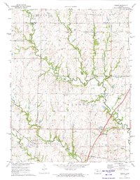
1971 Map of Admire
USGS Topo · Published 1973About this map
The town of Admire sits at a geographic crossroads in the early 1970s, where the Missouri Pacific railroad intersects with a landscape defined by rolling prairie and deep-cut creek beds. The area is heavily influenced by modern transportation infrastructure, most notably the Kansas Turnpike and its Admire Interchange to the east. Despite this highway presence, the map preserves the rural character of Lyon and Wabaunsee counties, showing community landmarks like the Community Hall and the Converse Farm Landing Strip.
Find a feature on this map
23 named features on this map. Tap any name to fly to it.
Don’t see what you’re looking for? This feature index may not catch every label — zoom into the map to look around manually.
Map Details
Editions of this 1971 Admire Map
This is the sole edition of this map. No revisions or reprints were ever made.
Other maps of this area

1885 · Eskridge
USGS Topo · 1:125,000

1889 · Burlingame
USGS Topo · 1:125,000

1889 · Eskridge
USGS Topo · 1:125,000

1894 · Eskridge
USGS Topo · 1:125,000

1894 · Burlingame
USGS Topo · 1:125,000

1947 · Lawrence
USGS Topo · 1:250,000

1950 · Lawrence
USGS Topo · 1:250,000

1952 · Harveyville
USGS Topo · 1:24,000

1955 · Hutchinson
USGS Topo · 1:250,000

1956 · Lawrence
USGS Topo · 1:250,000