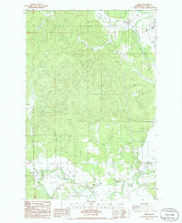
1986 Map of Adna
USGS Topo · Published 1986About this map
Adna and Littell sit along the lower southern corridor of this 1986 survey, marking the agricultural and residential development within the winding Chehalis River valley. This landscape is defined by the contrast between the flat river bottoms and the timbered elevations of Cook Hill and Scammon Hill. To the north, the Lincoln Creek Valley provides a secondary focal point for rural settlement near Galvin. Small communities like Claquato, Millburn, and Bunker are clustered near the river and rail lines, reflecting the historical transportation network of central Lewis County. Numerous small drainage systems, such as Sponenburgh Creek, Deep Creek, and Bunker Creek, terrace the hillsides, while modern landmarks like the KELA Radio Tower and the Fords Prairie Substation indicate the region's mid-century infrastructural growth.
Find a feature on this map
32 named features on this map. Tap any name to fly to it.
Don’t see what you’re looking for? This feature index may not catch every label — zoom into the map to look around manually.
Map Details
Editions of this 1986 Adna Map
2 editions found
Other maps of this area

1916 · Chehalis
USGS Topo · 1:125,000

1940 · Tenino
USGS Topo · 1:62,500

1941 · Meskill
USGS Topo · 1:62,500

1941 · Gate
USGS Topo · 1:62,500

1944 · Tenino
USGS Topo · 1:62,500

1949 · Tenino
USGS Topo · 1:62,500

1953 · Hoquiam
USGS Topo · 1:250,000

1953 · Rochester
USGS Topo · 1:62,500

1953 · Adna
USGS Topo · 1:62,500

1954 · Centralia
USGS Topo · 1:62,500