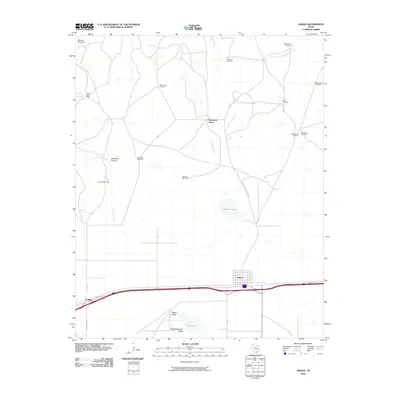
2010 Map of Adrian
USGS Topo · Published 2010About this map
The high plains landscape of Adrian and the surrounding ranchlands are defined by a network of essential water sources and rugged drainages. This early 21st-century survey reveals the critical role of windmills in the Texas Panhandle, with landmarks like Dead Man Windmill, Cottonwood Windmill, and White Knob Windmill marking the territory. The topography is shaped by seasonal watercourses such as Las Arches Creek and Bluff Creek, while the presence of Slaughterhouse Draw and Pigpen Draw south of the main settlement points to the area's agricultural and livestock roots. Small communities and rural outposts, including Gruhlkey and Wimberly Place, sit along the transport corridor of I-40 SVC RD, showing the modern evolution of the historic Route 66 corridor. Distinctive locations like Polar Bear Camp and Lost Mule Canyon add specific local character to this study of the Oldham County plains.
Find a feature on this map
28 named features on this map. Tap any name to fly to it.
Don’t see what you’re looking for? This feature index may not catch every label — zoom into the map to look around manually.
Map Details
Editions of this 2010 Adrian Map
This is the sole edition of this map. No revisions or reprints were ever made.
Other maps of this area

1954 · Tucumcari
USGS Topo · 1:250,000

1958 · Tucumcari
USGS Topo · 1:250,000

1966 · Boise
USGS Topo · 1:24,000

1966 · Alamocitos Camp
USGS Topo · 1:24,000

1966 · Simms NW
USGS Topo · 1:24,000

1966 · Simms NE
USGS Topo · 1:24,000

1966 · Adrian
USGS Topo · 1:24,000

1966 · Signal Spring SE
USGS Topo · 1:24,000

1966 · Big George Tank
USGS Topo · 1:24,000

1966 · Landergin
USGS Topo · 1:24,000