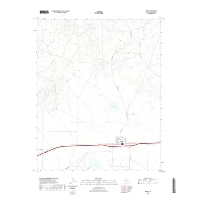
2019 Map of Adrian
USGS Topo · Published 2019About this map
Adrian serves as the primary hub of this High Plains landscape, situated along the Interstate 40 corridor where it intersects with FM 290. The town's grid is clearly defined by local thoroughfares such as Walnut Ave, Elm Ave, and E 5th St. To the west lies Gruhlkey, a smaller settlement marker along the same transport artery. The geography is characterized by significant drainage systems and ephemeral water sources that break the flat terrain, including the deeply etched Lost Mule Canyon and its associated Lost Mule Spring. Natural basins like Randall Lake and Rock Lake sit amidst ranching lands, while the northern reaches are defined by a network of waterways including Las Arches Creek and Bluff Creek. The naming of features like Slaughterhouse Draw and Pigpen Draw provides a direct connection to the region's agricultural and livestock history.
Find a feature on this map
26 named features on this map. Tap any name to fly to it.
Don’t see what you’re looking for? This feature index may not catch every label — zoom into the map to look around manually.
Map Details
Editions of this 2019 Adrian Map
This is the sole edition of this map. No revisions or reprints were ever made.
Other maps of this area

1954 · Tucumcari
USGS Topo · 1:250,000

1958 · Tucumcari
USGS Topo · 1:250,000

1966 · Boise
USGS Topo · 1:24,000

1966 · Alamocitos Camp
USGS Topo · 1:24,000

1966 · Simms NW
USGS Topo · 1:24,000

1966 · Simms NE
USGS Topo · 1:24,000

1966 · Adrian
USGS Topo · 1:24,000

1966 · Signal Spring SE
USGS Topo · 1:24,000

1966 · Big George Tank
USGS Topo · 1:24,000

1966 · Landergin
USGS Topo · 1:24,000