
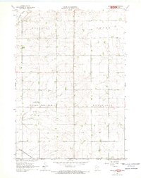
1967 Map of Adrian SW
USGS Topo · Published 1968About this map
The Minnesota-Iowa state line defines the southern edge of this 1967 survey, where Nobles County meets Lyon County. The landscape is a testament to the agricultural grid of the Upper Midwest, organized into the townships of Westside, Olney, Grand Prairie, and Little Rock. Waterways such as Kanaranzi Creek and Norwegian Creek meander across the terrain, providing natural breaks in the geometric section lines. In the southwestern corner, the Chicago Rock Island and Pacific railroad cuts a diagonal path across the landscape, marking a vital transportation artery for the region's rural economy. Scattered Gravel Pits indicate localized extraction efforts within this predominantly farming territory, while the map's fine-line detailing captures the precise placement of farmsteads and field boundaries as they stood in the late 1960s.
Find a feature on this map
10 named features on this map. Tap any name to fly to it.
Don’t see what you’re looking for? This feature index may not catch every label — zoom into the map to look around manually.
Map Details
Editions of this 1967 Adrian SW Map
2 editions found
Other maps of this area

1954 · Fairmont
USGS Topo · 1:250,000

1955 · Sioux Falls
USGS Topo · 1:250,000

1958 · Sioux Falls
USGS Topo · 1:250,000

1958 · Fairmont
USGS Topo · 1:250,000

1967 · Magnolia
USGS Topo · 1:24,000

1967 · Rushmore
USGS Topo · 1:24,000

1967 · Adrian NE
USGS Topo · 1:24,000

1967 · Adrian
USGS Topo · 1:24,000

1967 · Ellsworth
USGS Topo · 1:24,000

1971 · Edna
USGS Topo · 1:24,000