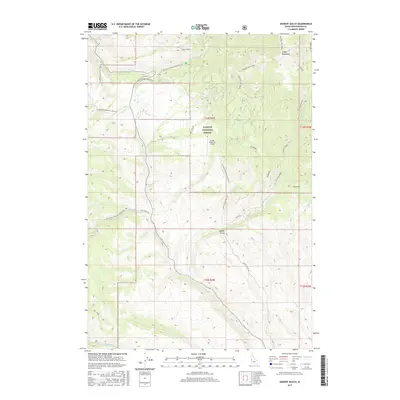
2017 Map of Advent Gulch
USGS Topo · Published 2017About this map
Cuddy Mountains dominate this high-elevation landscape within the Payette National Forest, where steep drainages and isolated meadows define the terrain. The map reveals a network of remote infrastructure, most notably the Cuddy Meadows Airport, which sits on a high plateau surrounded by the headwaters of Pine Cr and Cracker Jack Creek. This 2017 survey shows how the landscape is segmented by forest development roads like Natl Forest Develop Road 044 Trl and the Middle Fork Brownlee Creek Rd. The drainage patterns are intricate, with Advent Gulch cutting through the center of the sheet, while Fox Prairie offers a rare break in the timbered slopes to the east. This area reflects the modern management of Idaho's backcountry, balancing remote aviation access with the preservation of the Camp Creek and E Brownlee Cr watersheds.
Find a feature on this map
27 named features on this map. Tap any name to fly to it.
Don’t see what you’re looking for? This feature index may not catch every label — zoom into the map to look around manually.
Map Details
Editions of this 2017 Advent Gulch Map
This is the sole edition of this map. No revisions or reprints were ever made.
Other maps of this area

1955 · Baker
USGS Topo · 1:250,000

1957 · Cambridge
USGS Topo · 1:62,500

1957 · Copperfield
USGS Topo · 1:62,500

1957 · Hornet
USGS Topo · 1:62,500

1957 · Sturgill Peak
USGS Topo · 1:62,500

1959 · Baker
USGS Topo · 1:250,000

1980 · McCall
USGS Topo · 1:100,000
1986 · Crooked River Point
USGS Topo · 1:24,000
1986 · Cambridge
USGS Topo · 1:24,000
1986 · Rush Peak
USGS Topo · 1:24,000