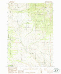
1987 Map of Advent Gulch
USGS Topo · Published 1987About this map
Payette National Forest dominates this Idaho landscape in the late 1980s, covering a high-elevation terrain defined by the Cuddy Mountains to the northeast and the Hitt Mountains to the southwest. The area is a hub of mountain drainage and forestry activity, evidenced by the centrally located Brownlee Ranger Station and the nearby Brownlee Campground along East Brownlee Creek. This 1987 provisional survey shows a network of creeks, including Seid Creek, Little Pine Creek, and Pine Creek, which carve out significant features like Long Gulch and Advent Gulch. Occasional industrial markers, such as a Prospect and a Gravel Pit, punctuate the landscape, hinting at the resource extraction and road maintenance necessary for this remote national forest region. The open expanse of Fox Prairie sits tucked between the peaks, providing a rare break in the timbered slopes.
Find a feature on this map
19 named features on this map. Tap any name to fly to it.
Don’t see what you’re looking for? This feature index may not catch every label — zoom into the map to look around manually.
Map Details
Editions of this 1987 Advent Gulch Map
This is the sole edition of this map. No revisions or reprints were ever made.
Other maps of this area

1955 · Baker
USGS Topo · 1:250,000

1957 · Cambridge
USGS Topo · 1:62,500

1957 · Copperfield
USGS Topo · 1:62,500

1957 · Hornet
USGS Topo · 1:62,500

1957 · Sturgill Peak
USGS Topo · 1:62,500

1959 · Baker
USGS Topo · 1:250,000

1980 · McCall
USGS Topo · 1:100,000
1986 · Crooked River Point
USGS Topo · 1:24,000
1986 · Cambridge
USGS Topo · 1:24,000
1986 · Rush Peak
USGS Topo · 1:24,000