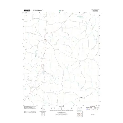
2011 Map of Afton
USGS Topo · Published 2011About this map
Afton and the neighboring settlements of Elberon and Parktown anchor this section of Warren County, where the landscape is defined by the headwaters of numerous creeks and branches. The road network reflects a long-established rural community, with family-named routes such as Boyd Farm Rd, Cornell Davis Rd, and Twitty Rd connecting these small hubs. A central feature of the northern terrain is the Hammes Mill Pond, supported by the Hammes Mill Pond Dam, which feeds into Fishing Creek. Further south, the map details the branching paths of Shocco Creek and Little Shocco Creek. Local water management is evident at Lake Largo, where the Lake Largo Dam regulates flow into the Lees Branch. In the southeast, the uniquely named Lickskillet sits near the intersection of several county roads, offering a clear look at the region's late-twentieth-century residential and agricultural footprint before further modern development.
Find a feature on this map
47 named features on this map. Tap any name to fly to it.
Don’t see what you’re looking for? This feature index may not catch every label — zoom into the map to look around manually.
Map Details
Editions of this 2011 Afton Map
This is the sole edition of this map. No revisions or reprints were ever made.
Other maps of this area

1953 · Greensboro
USGS Topo · 1:250,000

1954 · Greensboro
USGS Topo · 1:250,000

1962 · Greensboro
USGS Topo · 1:250,000

1966 · Greensboro
USGS Topo · 1:250,000
1970 · Macon
USGS Topo · 1:24,000

1970 · Vicksboro
USGS Topo · 1:24,000
1970 · Middleburg
USGS Topo · 1:24,000
1970 · Warrenton
USGS Topo · 1:24,000

1971 · Inez
USGS Topo · 1:24,000

1971 · Afton
USGS Topo · 1:24,000