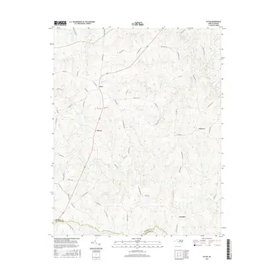
2016 Map of Afton
USGS Topo · Published 2016About this map
The crossroads of Afton and Elberon anchor this portion of the northern Piedmont, where the landscape is defined by the winding drainages of Shocco Cr and Little Shocco Cr. This 2016 survey documents a rural topography marked by numerous family-named roads and small residential clusters such as Parktown and the curiously named Lickskillet near the southern boundary. Significant water features like Hammes Mill Pond and Largo Lake suggest long-standing land use patterns tied to local milling and water management. The map also traces the Warren Co and Franklin Co boundary, illustrating how the political border follows the natural course of the Little Shocco Cr. Transportation is a central theme, with named thoroughfares like Stagecoach Rd and Perrytown Rd reflecting the area's historical connectivity.
Find a feature on this map
62 named features on this map. Tap any name to fly to it.
Don’t see what you’re looking for? This feature index may not catch every label — zoom into the map to look around manually.
Map Details
Editions of this 2016 Afton Map
This is the sole edition of this map. No revisions or reprints were ever made.
Other maps of this area

1953 · Greensboro
USGS Topo · 1:250,000

1954 · Greensboro
USGS Topo · 1:250,000

1962 · Greensboro
USGS Topo · 1:250,000

1966 · Greensboro
USGS Topo · 1:250,000
1970 · Macon
USGS Topo · 1:24,000

1970 · Vicksboro
USGS Topo · 1:24,000
1970 · Middleburg
USGS Topo · 1:24,000
1970 · Warrenton
USGS Topo · 1:24,000

1971 · Inez
USGS Topo · 1:24,000

1971 · Afton
USGS Topo · 1:24,000