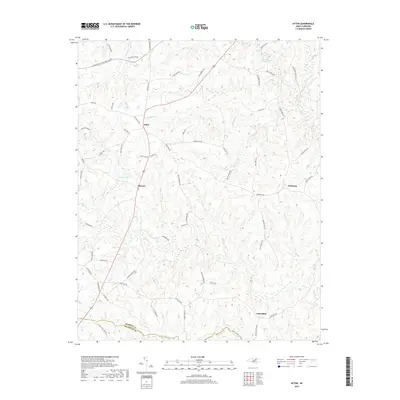
2019 Map of Afton
USGS Topo · Published 2019About this map
Afton and the neighboring settlements of Elberon and Parktown define the upper reaches of the North Carolina coastal plain near the Warren Co and Franklin Co line. This landscape is deeply etched by a network of waterways including Shocco Cr and the Little Shocco Cr, which create the undulating terrain typical of the region. The map captures a transition in local infrastructure, where modern corridors like Dr Martin Luther King Jr Blvd intersect with older routes such as Stagecoach Rd and Hamme Mill Rd. For the local historian, the map preserves the names of numerous family farms and local landmarks, from the waters of Hammes Mill Pond to the small community at Lickskillet in the south, reflecting the area's enduring rural character and agricultural roots.
Find a feature on this map
65 named features on this map. Tap any name to fly to it.
Don’t see what you’re looking for? This feature index may not catch every label — zoom into the map to look around manually.
Map Details
Editions of this 2019 Afton Map
This is the sole edition of this map. No revisions or reprints were ever made.
Other maps of this area

1953 · Greensboro
USGS Topo · 1:250,000

1954 · Greensboro
USGS Topo · 1:250,000

1962 · Greensboro
USGS Topo · 1:250,000

1966 · Greensboro
USGS Topo · 1:250,000
1970 · Macon
USGS Topo · 1:24,000

1970 · Vicksboro
USGS Topo · 1:24,000
1970 · Middleburg
USGS Topo · 1:24,000
1970 · Warrenton
USGS Topo · 1:24,000

1971 · Inez
USGS Topo · 1:24,000

1971 · Afton
USGS Topo · 1:24,000