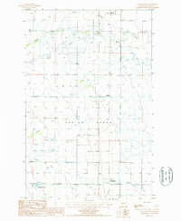
1987 Map of Agawam South
USGS Topo · Published 1987About this map
Burton Bench dominates this agricultural landscape of Teton County, where complex water management systems define the terrain. The presence of numerous flumes, ditches, and an Abandoned Canal illustrates the intensive efforts to irrigate this portion of the Montana plains during the late 20th century. Local commerce is centered on the Grain Elevators at Agawam and Farmington, marking the vital link between the prairie harvests and the transport network. Evidence of shifting transit patterns is visible in the Old RR Grade that runs north-south through the center of the sheet, passing by Malone and Agawam. The natural hydrology of Muddy Creek and Foster Creek is supplemented by man-made features like Glendora Lake and several irrigation reservoirs, while the Alkali Flat to the east highlights the alkaline soils common to the region.
Find a feature on this map
22 named features on this map. Tap any name to fly to it.
Don’t see what you’re looking for? This feature index may not catch every label — zoom into the map to look around manually.
Map Details
Editions of this 1987 Agawam South Map
This is the sole edition of this map. No revisions or reprints were ever made.
Other maps of this area

1920 · Choteau
USGS Topo · 1:125,000

1920 · Dupuyer
USGS Topo · 1:125,000

1936 · Pendroy
USGS Topo · 1:48,000

1938 · Gallup City
USGS Topo · 1:62,500

1941 · Pendroy
USGS Topo · 1:62,500

1942 · Gallup City
USGS Topo · 1:62,500

1955 · Choteau
USGS Topo · 1:250,000

1957 · Choteau
USGS Topo · 1:250,000

1958 · Choteau
USGS Topo · 1:250,000

1960 · Bynum
USGS Topo · 1:62,500