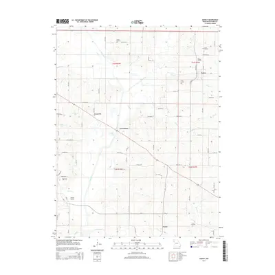
2014 Map of Agency
USGS Topo · Published 2014About this map
The Platte River snakes through the center of this Buchanan County landscape, defining the lowlands between the small settlements of Agency and Easton. In this modern era of mapping, the rural character of the region remains visible through the preservation of numerous family and parish burial grounds, including Saint Josephs Cemetery, Blakely Cemetery, and Karns Cemetery. These sites are often the last standing indicators of earlier pioneer family footprints near the river’s edge.
Find a feature on this map
69 named features on this map. Tap any name to fly to it.
Don’t see what you’re looking for? This feature index may not catch every label — zoom into the map to look around manually.
Map Details
Editions of this 2014 Agency Map
This is the sole edition of this map. No revisions or reprints were ever made.
Other maps of this area

1923 · Clarksdale
USGS Topo · 1:62,500

1924 · St. Joseph
USGS Topo · 1:62,500

1925 · Gower
USGS Topo · 1:62,500

1925 · Clarksdale
USGS Topo · 1:62,500

1926 · Saint Joseph
USGS Topo · 1:62,500

1927 · Dearborn
USGS Topo · 1:62,500

1950 · Kansas City
USGS Topo · 1:250,000

1951 · Edgerton
USGS Topo · 1:24,000
1951 · Gower
USGS Topo · 1:24,000
1951 · Dearborn
USGS Topo · 1:24,000