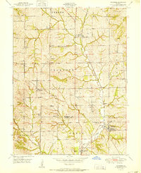
1951 Map of Dearborn
USGS Topo · Published 1951About this map
The town of Dearborn serves as a focal point in this 1951 survey, situated along the Chicago Great Western railroad line as it crosses the Buchanan Co Platte Co line. The map reveals a post-war landscape of rural Missouri, where the road network connects numerous family-named cemeteries and small community institutions. Educational hubs like Wallace Sch and Cox Sch are scattered across the townships of Crawford and Green, while religious and fraternal life is represented by Halleck Ch and the Dearborn Masonic Cem. The winding path of Bee Creek and its tributaries, such as Jordan Branch, dictate the varied topography, influencing the placement of smaller settlements like Wallace and Faucett along the rail and road corridors.
Find a feature on this map
35 named features on this map. Tap any name to fly to it.
Don’t see what you’re looking for? This feature index may not catch every label — zoom into the map to look around manually.
Map Details
Editions of this 1951 Dearborn Map
2 editions found
Other maps of this area

1890 · Kansas City
USGS Topo · 1:125,000

1894 · Kansas City
USGS Topo · 1:125,000

1910 · Leavenworth
USGS Topo · 1:62,500

1914 · Smithville
USGS Topo · 1:62,500

1925 · Gower
USGS Topo · 1:62,500

1927 · Dearborn
USGS Topo · 1:62,500

1948 · Leavenworth
USGS Topo · 1:62,500

1950 · Kansas City
USGS Topo · 1:250,000
1950 · Smithville
USGS Topo · 1:62,500

1951 · Edgerton
USGS Topo · 1:24,000