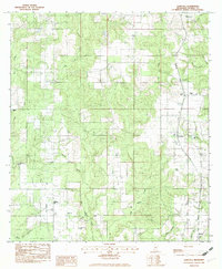
1982 Map of Agricola
USGS Topo · Published 1982About this map
Agricola and Barton anchor this portion of George County, Mississippi, where the landscape is defined by the winding drainages of Big Cedar Creek and Little Cedar Creek. The rural settlement pattern is marked by a high concentration of small community institutions, including Pine View Ch, Evangel Temple, and Barton Ch. Several family-named burial grounds like Finch Cem and Lee Cem suggest deep-rooted local lineages in this timbered region. Transport and industry of the late 1970s and early 1980s are represented by the Farmco Landing Strip and a Sand Pit, alongside the Shipman Lookout Tower overlooking the creek valleys. The presence of a Fairground and an Athl Field near the major creek systems indicates these areas served as social hubs for the surrounding farmsteads.
Find a feature on this map
31 named features on this map. Tap any name to fly to it.
Don’t see what you’re looking for? This feature index may not catch every label — zoom into the map to look around manually.
Map Details
Editions of this 1982 Agricola Map
This is the sole edition of this map. No revisions or reprints were ever made.
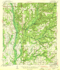
Other maps of this area

1941 · Hurley
USGS Topo · 1:62,500

1941 · Vancleave
USGS Topo · 1:62,500

1941 · Lucedale
USGS Topo · 1:62,500

1942 · Wilmer
USGS Topo · 1:62,500

1943 · Lucedale
USGS Topo · 1:62,500
1943 · Hurley
USGS Topo · 1:62,500

1943 · Vancleave
USGS Topo · 1:62,500

1944 · Wilmer
USGS Topo · 1:62,500

1944 · Vancleave
USGS Topo · 1:62,500

1953 · Mobile
USGS Topo · 1:250,000