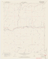
1960 Map of Agua Dulce
USGS Topo · Published 1965About this map
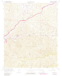
Vasquez Rocks rise from the high desert landscape of this 1960 field-checked survey, a period when the Agua Dulce area maintained its rural character before significant suburban expansion. The Southern Pacific railroad corridor serves as the primary artery through the canyon, connecting the small settlements of Russ and Lang. To the south, the terrain climbs toward the high peaks of the Angeles National Forest, including the Military Reservation atop Magic Mtn. The map reveals a utilitarian landscape of the early 1960s, featuring the Agua Dulce Air Park, a Soledad Guard Sta, and the County Detention Camp No 1. Numerous named canyons like Escondido Canyon and Agua Dulce Canyon drain toward the Santa Clara River, illustrating the complex drainage patterns that define this section of the Sierra Pelona Mountains.
Find a feature on this map
64 named features on this map. Tap any name to fly to it.
Don’t see what you’re looking for? This feature index may not catch every label — zoom into the map to look around manually.
Map Details
Editions of this 1960 Agua Dulce Map
7 editions found
Other maps of this area

1900 · Tujunga
USGS Topo · 1:62,500

1900 · Fernando
USGS Topo · 1:62,500

1901 · Southern California Sheet No. 1
USGS Topo · 1:250,000

1904 · Southern California Sheet No. 1
USGS Topo · 1:250,000

1915 · Elizabeth Lake
USGS Topo · 1:125,000

1917 · Elizabeth Lake
USGS Topo · 1:125,000

1929 · Lang
USGS Topo · 1:24,000

1930 · Ravenna
USGS Topo · 1:24,000

1932 · Red Rover
USGS Topo · 1:24,000
1932 · Mint Canyon
USGS Topo · 1:24,000