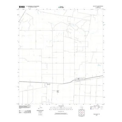
2010 Map of Agua Dulce
USGS Topo · Published 2010About this map
Agua Dulce stands as the primary hub in this coastal prairie landscape, where the town layout reflects a grid-like development south of Agua Dulce Creek. The 2010 geography is defined by an intricate network of drainage ways including Palo Hueco Creek, Rosita Creek, and Tecolote Creek, which carve gentle paths through the agricultural fields and ranchlands of Nueces County. The map details the transition from rural land use to residential pockets, evidenced by the presence of Bentonville and the Harvest Acres Colonia further south. Notable rural landmarks like Morgan Alfred Rd and Groneveld Dairy Rd suggest the enduring importance of family-held agricultural land and dairy operations in the region. Transportation routes like Old State Hwy 44 parallel newer corridors, marking the evolution of transit across this south Texas plain.
Find a feature on this map
39 named features on this map. Tap any name to fly to it.
Don’t see what you’re looking for? This feature index may not catch every label — zoom into the map to look around manually.
Map Details
Editions of this 2010 Agua Dulce Map
This is the sole edition of this map. No revisions or reprints were ever made.
Other maps of this area

1917 · Ben Bolt
USGS Topo · 1:62,500

1920 · San Diego
USGS Topo · 1:62,500

1950 · Corpus Christi
USGS Topo · 1:250,000

1954 · Orange Grove
USGS Topo · 1:62,500

1954 · Kingsville
USGS Topo · 1:62,500

1956 · Corpus Christi
USGS Topo · 1:250,000

1956 · Laredo
USGS Topo · 1:250,000

1960 · Corpus Christi
USGS Topo · 1:250,000

1963 · San Diego NE
USGS Topo · 1:24,000
1963 · Alice North
USGS Topo · 1:24,000
Featured Places
- Agua Dulce, TX
- Bentonville, TX
- Harvest Acres Colonia, TX
- Palo Hueco Estates Colonia, TX
- Nueces County, TX