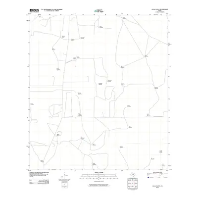
2010 Map of Agua Nueva
USGS Topo · Published 2010About this map
Agua Nueva and the surrounding ranchlands of Jim Hogg County are defined by a network of essential water points in this South Texas landscape. This survey illustrates the vital role of wind power in sustaining the local cattle industry, marking dozens of named wells such as Loma Windmill, San Carlos Windmill, and Buena Suerte Windmill. These features, often the only landmarks for miles, are connected by isolated ranch roads like Las Palomas Ranch Rd and Alice Jones Thompson Rd. Local genealogy is anchored by the Ramirez Cemetery, while the presence of Palomas Ranch and the Puesta Del Sol Airport points to the modernization of these large private holdings. The map provides a clear picture of the grid-like partitioning of the brush country, where transportation is funneled through FM 1017 and Agua Nueva Rd.
Find a feature on this map
35 named features on this map. Tap any name to fly to it.
Don’t see what you’re looking for? This feature index may not catch every label — zoom into the map to look around manually.
Map Details
Editions of this 2010 Agua Nueva Map
This is the sole edition of this map. No revisions or reprints were ever made.
Other maps of this area

1921 · Falfurrias
USGS Topo · 1:125,000

1938 · Agua Nueva
USGS Topo · 1:62,500

1939 · Encantada
USGS Topo · 1:62,500

1949 · Mc Allen
USGS Topo · 1:250,000

1954 · McAllen
USGS Topo · 1:250,000

1956 · Laredo
USGS Topo · 1:250,000

1957 · Mc Allen
USGS Topo · 1:250,000

1962 · McAllen
USGS Topo · 1:250,000

1968 · Palomas Ranch SW
USGS Topo · 1:24,000
1972 · Alta Vista Ranch SW
USGS Topo · 1:24,000