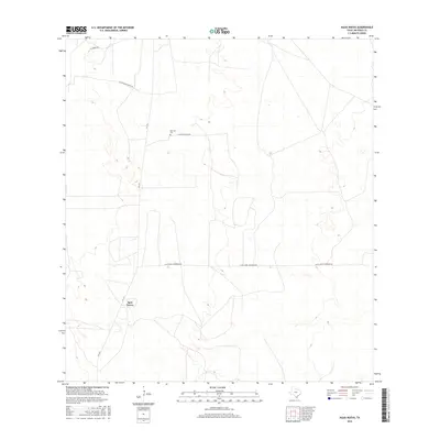
2016 Map of Agua Nueva
USGS Topo · Published 2016About this map
Agua Nueva anchors this South Texas landscape in Jim Hogg County, situated along the corridor of FM 1017. The area is defined by a sparse network of ranch roads that reflect the region's long-standing pastoral economy and large landholdings. Notable among these are Alice Jones Thompson Rd and Las Palomas Ranch Rd, which cut through the arid terrain to connect various rural homesteads. A significant point of interest for genealogists and local historians is the Ramirez Cem, located off La Salada Ranch Rd. This small burial ground serves as a quiet marker of the family lineages that have managed these South Texas plains for generations. The map illustrates a transition from the primary thoroughfare to more isolated routes like El Reposo Rd, showing how the modern infrastructure integrates with older ranching boundaries.
Find a feature on this map
7 named features on this map. Tap any name to fly to it.
Don’t see what you’re looking for? This feature index may not catch every label — zoom into the map to look around manually.
Map Details
Editions of this 2016 Agua Nueva Map
This is the sole edition of this map. No revisions or reprints were ever made.
Other maps of this area

1921 · Falfurrias
USGS Topo · 1:125,000

1938 · Agua Nueva
USGS Topo · 1:62,500

1939 · Encantada
USGS Topo · 1:62,500

1949 · Mc Allen
USGS Topo · 1:250,000

1954 · McAllen
USGS Topo · 1:250,000

1956 · Laredo
USGS Topo · 1:250,000

1957 · Mc Allen
USGS Topo · 1:250,000

1962 · McAllen
USGS Topo · 1:250,000

1968 · Palomas Ranch SW
USGS Topo · 1:24,000
1972 · Alta Vista Ranch SW
USGS Topo · 1:24,000