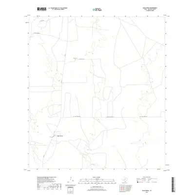
2019 Map of Agua Nueva
USGS Topo · Published 2019About this map
Agua Nueva sits at the center of this South Texas landscape, where the ranching heritage of Jim Hogg County is etched into the road network. The map reveals a remote territory organized by family-named tracks and long-established ranch properties, such as those accessed via Las Palomas Ranch Rd and La Salada Ranch Rd. A primary north-south artery, FM 1017, connects these disparate holdings, passing near the small settlement of Agua Nueva and its namesake Agua Nueva Ranch Rd. Local genealogy is anchored by the Ramirez Cem, located along the route toward the northern boundary. The terrain is marked by the unique horizontal divide of Alice Jones Thompson Rd, which stretches across the center of the quadrangle, illustrating the vast scale of land ownership and rural life in this part of the Brush Country during the late 2010s.
Find a feature on this map
8 named features on this map. Tap any name to fly to it.
Don’t see what you’re looking for? This feature index may not catch every label — zoom into the map to look around manually.
Map Details
Editions of this 2019 Agua Nueva Map
This is the sole edition of this map. No revisions or reprints were ever made.
Other maps of this area

1921 · Falfurrias
USGS Topo · 1:125,000

1938 · Agua Nueva
USGS Topo · 1:62,500

1939 · Encantada
USGS Topo · 1:62,500

1949 · Mc Allen
USGS Topo · 1:250,000

1954 · McAllen
USGS Topo · 1:250,000

1956 · Laredo
USGS Topo · 1:250,000

1957 · Mc Allen
USGS Topo · 1:250,000

1962 · McAllen
USGS Topo · 1:250,000

1968 · Palomas Ranch SW
USGS Topo · 1:24,000
1972 · Alta Vista Ranch SW
USGS Topo · 1:24,000