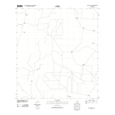
2010 Map of Agua Nueva SE
USGS Topo · Published 2010About this map
Las Comitas Ranch and Ramirito Ranch characterize the ranching landscape of Starr County in the early twenty-first century. This territory is defined by a sparse network of private roads like Borregos Ranch Rd and Ramirito Rd that connect isolated homesteads and vital water infrastructure. The distribution of named water sources, such as Noria de Llano Windmill, San Manuel Windmill, and Brazil Windmill, illustrates the continued importance of groundwater for agricultural operations in this arid region. Near the southern edge, La Libertad Ranch and Sanbenito Ranch sit adjacent to FM 1017, while Mancia Ranch anchors the southeastern corner. The map reveals a specialized settlement pattern where residential life is inextricably tied to large-scale land holdings and the mechanical maintenance of the local water supply.
Find a feature on this map
18 named features on this map. Tap any name to fly to it.
Don’t see what you’re looking for? This feature index may not catch every label — zoom into the map to look around manually.
Map Details
Editions of this 2010 Agua Nueva SE Map
This is the sole edition of this map. No revisions or reprints were ever made.
Other maps of this area

1938 · Agua Nueva
USGS Topo · 1:62,500

1938 · Sal Colorada
USGS Topo · 1:62,500

1939 · La Reforma
USGS Topo · 1:62,500

1939 · Encantada
USGS Topo · 1:62,500

1949 · Mc Allen
USGS Topo · 1:250,000

1954 · McAllen
USGS Topo · 1:250,000

1957 · Mc Allen
USGS Topo · 1:250,000

1962 · McAllen
USGS Topo · 1:250,000
1972 · San Isidro
USGS Topo · 1:24,000
1972 · Santa Elena NW
USGS Topo · 1:24,000