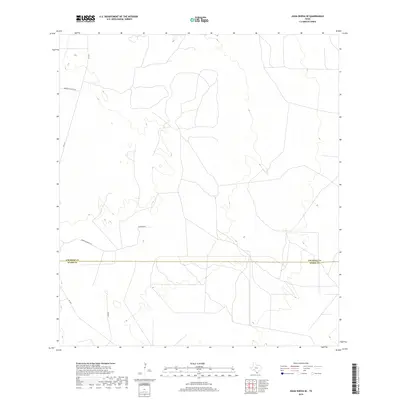
2019 Map of Agua Nueva SE
USGS Topo · Published 2019About this map
Jim Hogg Co and Starr Co meet along a straight east-west boundary in this South Texas ranching landscape. The area is defined by a sparse network of rural roads and cattle routes, reflecting the expansive landholdings typical of the Rio Grande Valley hinterlands. Significant local access is provided by FM 1017, which cuts across the western portion of the map, while private and ranch roads such as Borregos Ranch Rd and Ramirito Ranch Rd suggest long-standing family land partitions. The terrain is relatively uniform, with small variations in elevation indicated by fine contour lines, and the remote nature of the settlement is highlighted by the singular mention of Jonquil and the various ranch tracks like Ramirito Rd that weave through the brush country.
Find a feature on this map
6 named features on this map. Tap any name to fly to it.
Don’t see what you’re looking for? This feature index may not catch every label — zoom into the map to look around manually.
Map Details
Editions of this 2019 Agua Nueva SE Map
This is the sole edition of this map. No revisions or reprints were ever made.
Other maps of this area

1938 · Agua Nueva
USGS Topo · 1:62,500

1938 · Sal Colorada
USGS Topo · 1:62,500

1939 · La Reforma
USGS Topo · 1:62,500

1939 · Encantada
USGS Topo · 1:62,500

1949 · Mc Allen
USGS Topo · 1:250,000

1954 · McAllen
USGS Topo · 1:250,000

1957 · Mc Allen
USGS Topo · 1:250,000

1962 · McAllen
USGS Topo · 1:250,000
1972 · San Isidro
USGS Topo · 1:24,000
1972 · Santa Elena NW
USGS Topo · 1:24,000