1950 Map of Aguadilla SE
USGS Topo · Published 1950About this map
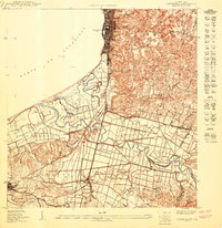
Aguadilla serves as the focal point of this coastal survey, where the urban grid meets the Bahía de Aguadilla. The coastal strip is densely populated with neighborhoods like Tamarindo, Santa Barbara, and Higuey, transitioning into the industrial and transportation corridor defined by the American Railroad. To the south, the meandering Río Culebrinas carves through the landscape of Espinal and Carrizal, supporting a rural-to-urban transition. Local institutional life is anchored by landmarks such as the Escuela Segunda Unidad Espinal and the recreational Parque de Colón. The map reveals a complex drainage network including the Caño Madre Vieja and several named hills like Cerro Vadi, reflecting the varied topography of the Municipio de Aguadilla and its neighboring districts at mid-century.
Find a feature on this map
34 named features on this map. Tap any name to fly to it.
Don’t see what you’re looking for? This feature index may not catch every label — zoom into the map to look around manually.
Map Details
Editions of this 1950 Aguadilla SE Map
This is the sole edition of this map. No revisions or reprints were ever made.
Other maps of this area

1937 · Aguadilla
USGS Topo · 1:20,000

1937 · Moca
USGS Topo · 1:20,000

1938 · Alto Sano
USGS Topo · 1:20,000

1941 · Moca
USGS Topo · 1:30,000

1941 · Rincon
USGS Topo · 1:30,000

1941 · Rincon
USGS Topo · 1:30,000

1942 · Moca
USGS Topo · 1:30,000

1942 · Central La Plata
USGS Topo · 1:30,000

1942 · Aguadilla
USGS Topo · 1:30,000

1946 · Ciales
USGS Topo · 1:30,000
Featured Places
- Aguadilla, Aguadilla
- Las Golondrinas, Aguadilla
- Sector Los Cocos, Moca
- Cerro Juan Vega, Aguadilla
- Sector Monte Brujo, Aguadilla