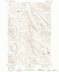
1960 Map of Ahles
USGS Topo · Published 1984About this map
Starved to Death Creek carves a winding path through this corner of Eastern Montana, defining a landscape of sharp coulees and intermittent drainages. The small settlement of Ahles sits along an Old Railroad Grade that cuts diagonally across the northern terrain, indicating a former transport corridor that once connected these remote stretches of the Treasure and Rosebud county line. The map reveals a geography marked by strikingly named watercourses, including Frozen to Death Creek and Geyser Spring Coulee, which suggest the harsh environmental conditions faced by early ranchers and travelers in the region. This 1960 survey, updated with 1980 photorevisions, provides a detailed record of the livestock reservoirs and property boundaries that characterize the local land use between Hyatt Creek and the surrounding high plains.
Find a feature on this map
8 named features on this map. Tap any name to fly to it.
Don’t see what you’re looking for? This feature index may not catch every label — zoom into the map to look around manually.
Map Details
Editions of this 1960 Ahles Map
2 editions found
Other maps of this area

1954 · Forsyth
USGS Topo · 1:250,000

1957 · Forsyth
USGS Topo · 1:250,000

1958 · Forsyth
USGS Topo · 1:250,000

1960 · Hysham
USGS Topo · 1:24,000

1960 · Steie Ranch
USGS Topo · 1:24,000

1960 · Vananda
USGS Topo · 1:24,000

1960 · Ahles
USGS Topo · 1:24,000

1960 · Myers
USGS Topo · 1:24,000

1960 · Sanders
USGS Topo · 1:24,000

1960 · Thebes
USGS Topo · 1:24,000