
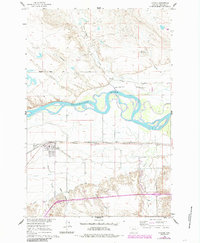
1960 Map of Hysham
USGS Topo · Published 1962About this map
Hysham serves as the focal point of this Treasure County landscape, situated along the southern banks of the Yellowstone River. The area’s agricultural character is defined by an intricate network of irrigation infrastructure, including the Yellowstone Canal, Hysham Main Canal, and Box Elder Ditch, which redirect water into the dry terrain of Mission Valley. This reliance on the river and its diverted channels highlights the transformation of the prairie into productive farmland during the mid-20th century.
Find a feature on this map
24 named features on this map. Tap any name to fly to it.
Don’t see what you’re looking for? This feature index may not catch every label — zoom into the map to look around manually.
Map Details
Editions of this 1960 Hysham Map
2 editions found
Other maps of this area

1954 · Forsyth
USGS Topo · 1:250,000

1957 · Forsyth
USGS Topo · 1:250,000

1958 · Forsyth
USGS Topo · 1:250,000

1960 · Steie Ranch
USGS Topo · 1:24,000

1960 · Vananda
USGS Topo · 1:24,000

1960 · Ahles
USGS Topo · 1:24,000

1960 · Myers
USGS Topo · 1:24,000

1960 · Sanders
USGS Topo · 1:24,000

1960 · Eldering Ranch
USGS Topo · 1:24,000
1972 · Scraper Coulee
USGS Topo · 1:24,000