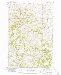
1972 Map of Scraper Coulee
USGS Topo · Published 1975About this map
Sarpy Creek flows through the eastern edge of this landscape, carving a valley that serves as a primary corridor for the Burlington Northern railroad and the Sarpy Road. The surrounding terrain is defined by a dense network of coulees, such as Scraper Coulee, Miller Coulee, and Whitcomb Coulee, which drain into the larger creek systems. These landforms reveal a dry, dissected upland where water sources were critical for ranching operations, evidenced by the numerous springs including Garverich Spring and Shadyock Spring.
Find a feature on this map
20 named features on this map. Tap any name to fly to it.
Don’t see what you’re looking for? This feature index may not catch every label — zoom into the map to look around manually.
Map Details
Editions of this 1972 Scraper Coulee Map
2 editions found
Other maps of this area

1954 · Forsyth
USGS Topo · 1:250,000

1957 · Forsyth
USGS Topo · 1:250,000

1958 · Forsyth
USGS Topo · 1:250,000

1960 · Hysham
USGS Topo · 1:24,000

1960 · Myers
USGS Topo · 1:24,000

1960 · Sanders
USGS Topo · 1:24,000

1960 · Eldering Ranch
USGS Topo · 1:24,000

1960 · Hope Ranch
USGS Topo · 1:24,000
1972 · Minnehaha Creek North
USGS Topo · 1:24,000
1972 · South Bear Creek
USGS Topo · 1:24,000