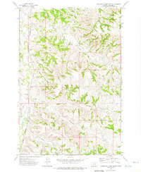
1972 Map of Minnehaha Creek North
USGS Topo · Published 1975About this map
Sarpy Creek and Beaver Creek wind through a complex network of coulees and ridges in Treasure County, defining a landscape of traditional Montana ranching in the early 1970s. The prominent Burlington Northern railroad corridor tracks along the western edge, providing a vital industrial link through this rural terrain. Local community life is anchored by the Petersen Ranch and the Beaver Creek Sch, while the many drainages like Outlaw Coulee and Sawmill Coulee suggest a history of seasonal water management and land use. This survey illustrates the intricate topography where South Fork Minnehaha Creek begins to form, showing the transition from higher rangeland to the creek bottoms used for livestock and travel.
Find a feature on this map
14 named features on this map. Tap any name to fly to it.
Don’t see what you’re looking for? This feature index may not catch every label — zoom into the map to look around manually.
Map Details
Editions of this 1972 Minnehaha Creek North Map
This is the sole edition of this map. No revisions or reprints were ever made.
Other maps of this area

1954 · Hardin
USGS Topo · 1:250,000

1954 · Forsyth
USGS Topo · 1:250,000

1957 · Hardin
USGS Topo · 1:250,000

1957 · Forsyth
USGS Topo · 1:250,000

1958 · Forsyth
USGS Topo · 1:250,000

1958 · Hardin
USGS Topo · 1:250,000

1971 · Mc Clure Creek
USGS Topo · 1:24,000

1971 · Griffin Coulee SW
USGS Topo · 1:24,000
1971 · Griffin Coulee NW
USGS Topo · 1:24,000

1972 · Minnehaha Creek South
USGS Topo · 1:24,000