
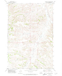
1971 Map of Griffin Coulee SW
USGS Topo · Published 1974About this map
The county line between Treasure Co and Rosebud Co bisects this Montana landscape, where the drainage systems of the Yellowstone River watershed dictate the terrain. Surveyed in the early 1970s, the map reveals a rugged network of coulees and ridges defined by the headwaters of Beaver Creek and the branching paths of Reservation Creek. The presence of a Drill Hole in the high ground between Bear Creek and West Sheep Creek points to early industrial exploration in this sparsely settled region. Numerous seasonal watercourses and a labeled Spring in the southeast corner underscore the importance of water management in this cattle-ranching territory. This survey documents the area before significant modern development, showing the complex topography that shaped early Montana land use and political boundaries.
Find a feature on this map
12 named features on this map. Tap any name to fly to it.
Don’t see what you’re looking for? This feature index may not catch every label — zoom into the map to look around manually.
Map Details
Editions of this 1971 Griffin Coulee SW Map
This is the sole edition of this map. No revisions or reprints were ever made.
Other maps of this area

1954 · Hardin
USGS Topo · 1:250,000

1954 · Forsyth
USGS Topo · 1:250,000

1957 · Hardin
USGS Topo · 1:250,000

1957 · Forsyth
USGS Topo · 1:250,000

1958 · Forsyth
USGS Topo · 1:250,000

1958 · Hardin
USGS Topo · 1:250,000

1971 · Trail Creek School
USGS Topo · 1:24,000

1971 · Mc Clure Creek
USGS Topo · 1:24,000

1971 · Griffin Coulee NE
USGS Topo · 1:24,000
1971 · Griffin Coulee
USGS Topo · 1:24,000