
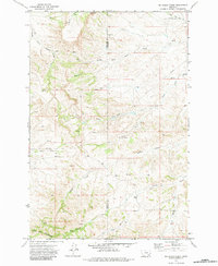
1971 Map of Mc Clure Creek
USGS Topo · Published 1974About this map
The Little Wolf Mountains dominate this 1971 landscape along the Treasure Co and Rosebud Co line in Montana. The terrain is defined by a dense network of seasonal drainages, including the South Fork Beaver Creek and Middle Fork Beaver Creek, which carve deep patterns into the high country. Human presence is sparse, marked primarily by a specialized transport network of a Landing Strip, a lone Pipeline, and numerous Jeep Trails that traverse the ridges. This environment reflects a working landscape of ranching and resource management, where named water sources like McClure Creek, Robbie Creek, and Donley Creek serve as critical landmarks for navigating the high-relief topography of the region.
Find a feature on this map
14 named features on this map. Tap any name to fly to it.
Don’t see what you’re looking for? This feature index may not catch every label — zoom into the map to look around manually.
Map Details
Editions of this 1971 Mc Clure Creek Map
2 editions found
Other maps of this area

1954 · Hardin
USGS Topo · 1:250,000

1954 · Forsyth
USGS Topo · 1:250,000

1957 · Hardin
USGS Topo · 1:250,000

1957 · Forsyth
USGS Topo · 1:250,000

1958 · Forsyth
USGS Topo · 1:250,000

1958 · Hardin
USGS Topo · 1:250,000

1971 · Trail Creek School
USGS Topo · 1:24,000

1971 · Griffin Coulee SW
USGS Topo · 1:24,000

1971 · Rough Draw
USGS Topo · 1:24,000
1971 · Sarpy School
USGS Topo · 1:24,000