
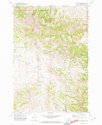
1971 Map of Rough Draw
USGS Topo · Published 1974About this map
The Little Wolf Mountains dominate the western edge of this Rosebud County landscape, marking a transition into the drainage basins of West Fork Armells Creek and East Fork Armells Creek. This 1971 survey reveals a territory defined by seasonal watercourses and high plains topography, where land use is dictated by the rugged coulees and draws. The southern portion of the sheet is characterized by Rough Draw and Slough Grass Creek, which cut through the high ground in an intricate network of erosion.
Find a feature on this map
15 named features on this map. Tap any name to fly to it.
Don’t see what you’re looking for? This feature index may not catch every label — zoom into the map to look around manually.
Map Details
Editions of this 1971 Rough Draw Map
This is the sole edition of this map. No revisions or reprints were ever made.
Other maps of this area

1954 · Hardin
USGS Topo · 1:250,000

1957 · Hardin
USGS Topo · 1:250,000

1958 · Hardin
USGS Topo · 1:250,000

1958 · Chalky Point
USGS Topo · 1:24,000

1958 · Jimtown
USGS Topo · 1:24,000

1958 · Black Spring
USGS Topo · 1:24,000

1971 · Trail Creek School
USGS Topo · 1:24,000

1971 · Colstrip SW
USGS Topo · 1:24,000

1971 · Mc Clure Creek
USGS Topo · 1:24,000
1971 · Sarpy School
USGS Topo · 1:24,000