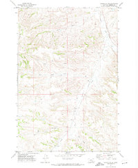
1971 Map of Griffin Coulee
USGS Topo · Published 1974About this map
Griffin Coulee and the surrounding drainage basins of Rosebud County define this landscape as it appeared in the early 1970s. The terrain is deeply incised by watercourses such as Armells Creek and its major tributary, West Fork Armells Creek, reflecting the complex erosion patterns typical of the Montana plains. Settlement is sparse, represented by the Gillin Ranch in the southern portion of the quadrangle. Industrial development is evident through the presence of a significant Pipeline corridor and the Burlington Northern railroad line, which follows the valley of Armells Creek. The map also identifies a Drill Hole south of West Sheep Creek, signaling subsurface exploration during this era. Other notable water features include the forks of West Cromo Creek and East Cromo Creek, providing a detailed look at the local geography used by ranchers and land managers.
Find a feature on this map
15 named features on this map. Tap any name to fly to it.
Don’t see what you’re looking for? This feature index may not catch every label — zoom into the map to look around manually.
Map Details
Editions of this 1971 Griffin Coulee Map
This is the sole edition of this map. No revisions or reprints were ever made.
Other maps of this area

1954 · Hardin
USGS Topo · 1:250,000

1954 · Forsyth
USGS Topo · 1:250,000

1957 · Hardin
USGS Topo · 1:250,000

1957 · Forsyth
USGS Topo · 1:250,000

1958 · Forsyth
USGS Topo · 1:250,000

1958 · Hardin
USGS Topo · 1:250,000

1971 · Trail Creek School
USGS Topo · 1:24,000

1971 · Mc Clure Creek
USGS Topo · 1:24,000

1971 · Griffin Coulee SW
USGS Topo · 1:24,000

1971 · Griffin Coulee NE
USGS Topo · 1:24,000