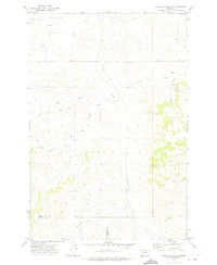
1971 Map of Griffin Coulee NW
USGS Topo · Published 1975About this map
Reservation Creek snakes through the center of this rangeland survey, carving a path between the high, broken plateaus of Rosebud and Treasure Counties. The landscape is defined by its drainage patterns, where significant topographic relief is marked by features like Cache Coulee and Wyant Coulee. These coulees and the broader Dog Prairie provide a glimpse into the cattle country of eastern Montana in the early 1970s. Human presence is sparse, indicated primarily by a network of Jeep Trails and scattered water sources such as Springs and a Well. In the southern reaches, the terrain descends toward East Fork Cottonwood Creek and Blacktail Creek, tracing the remote boundary line between neighboring counties in a region largely untouched by major infrastructure.
Find a feature on this map
13 named features on this map. Tap any name to fly to it.
Don’t see what you’re looking for? This feature index may not catch every label — zoom into the map to look around manually.
Map Details
Editions of this 1971 Griffin Coulee NW Map
This is the sole edition of this map. No revisions or reprints were ever made.
Other maps of this area

1954 · Forsyth
USGS Topo · 1:250,000

1957 · Forsyth
USGS Topo · 1:250,000

1958 · Forsyth
USGS Topo · 1:250,000

1960 · Sanders
USGS Topo · 1:24,000

1968 · Nichols
USGS Topo · 1:24,000

1968 · Finch
USGS Topo · 1:24,000

1971 · Griffin Coulee SW
USGS Topo · 1:24,000

1971 · Griffin Coulee NE
USGS Topo · 1:24,000
1971 · Griffin Coulee
USGS Topo · 1:24,000
1972 · Minnehaha Creek North
USGS Topo · 1:24,000