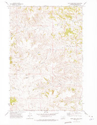
1972 Map of South Bear Creek
USGS Topo · Published 1975About this map
The drainage network of the Big Horn and Yellowstone river basins defines this 1972 survey, centered on the dissected uplands of Treasure County. West Bear Creek and South Bear Creek carve through the northern terrain, while Crystal Creek and East Burnt Creek dominate the south, creating a landscape of sharply defined ridges and coulees. A singular point of human activity is found at Barnes Ranch, situated in the shadow of the prominent Whiskey Butte. The map reflects a period of resource exploration and infrastructure development in this ranching country, marked by scattered Well sites and a prominent Radio Tower in the west. To the southeast, the course of Sarpy Creek cuts through the hills, providing a glimpse into the hydraulic patterns and land use of this Treasure County region during the early 1970s.
Find a feature on this map
10 named features on this map. Tap any name to fly to it.
Don’t see what you’re looking for? This feature index may not catch every label — zoom into the map to look around manually.
Map Details
Editions of this 1972 South Bear Creek Map
This is the sole edition of this map. No revisions or reprints were ever made.
Other maps of this area

1954 · Hardin
USGS Topo · 1:250,000

1954 · Forsyth
USGS Topo · 1:250,000

1957 · Hardin
USGS Topo · 1:250,000

1957 · Forsyth
USGS Topo · 1:250,000

1958 · Forsyth
USGS Topo · 1:250,000

1958 · Hardin
USGS Topo · 1:250,000

1960 · Eldering Ranch
USGS Topo · 1:24,000

1960 · Hope Ranch
USGS Topo · 1:24,000

1972 · Hammond Ranch
USGS Topo · 1:24,000

1972 · Minnehaha Creek South
USGS Topo · 1:24,000