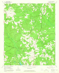
1964 Map of Aiken NW
USGS Topo · Published 1965About this map
The South Fork Edisto River forms a significant geographical spine in this northwestern section of Aiken County, where a landscape of small branches and creeks defines the local topography. In the mid-1960s, this area was characterized by a network of rural crossroads and community landmarks, such as Seiglers Crossroads and Center Sch. The presence of several claypits suggests a local industry tied to the region's natural deposits, while the Aiken Municipal Airport and its adjacent Airport Ch mark the modernization of the landscape.
Find a feature on this map
60 named features on this map. Tap any name to fly to it.
Don’t see what you’re looking for? This feature index may not catch every label — zoom into the map to look around manually.
Map Details
Editions of this 1964 Aiken NW Map
2 editions found
Other maps of this area

1920 · Aiken
USGS Topo · 1:48,000

1921 · Aiken
USGS Topo · 1:62,500

1923 · Warrenville
USGS Topo · 1:48,000

1928 · Warrenville
USGS Topo · 1:62,500

1943 · Aiken
USGS Topo · 1:62,500

1943 · Warrenville
USGS Topo · 1:62,500

1954 · Augusta
USGS Topo · 1:250,000

1957 · Augusta
USGS Topo · 1:250,000

1958 · Augusta
USGS Topo · 1:250,000

1961 · Augusta
USGS Topo · 1:250,000