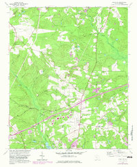
1964 Map of Aiken NW
USGS Topo · Published 1982About this map
The South Fork Edisto River winds through the northeast corner of this landscape, its tributaries like Jumping Gut and Mile Branch carving the terrain northwest of Seiglers Crossroads. This 1964 survey, revised in 1982, reveals a rural landscape defined by family legacies and industrial infrastructure. Multiple family burial grounds, including the Timmerman Cem and Seigler Cem, are preserved alongside small community hubs like Center Sch and Shiloh Ch. The southern portion of the map shows significant modernization with the presence of the Aiken Municipal Airport and its associated Beacon. Extensive clay extraction is evident through several marked Claypit sites, while significant energy infrastructure is indicated by the prominent Pipeline corridor crossing the area. Notable landmarks such as Camp Ne Kia and Aiken Waterworks further reflect the region's development during the mid-to-late 20th century.
Find a feature on this map
50 named features on this map. Tap any name to fly to it.
Don’t see what you’re looking for? This feature index may not catch every label — zoom into the map to look around manually.
Map Details
Editions of this 1964 Aiken NW Map
2 editions found
Other maps of this area

1920 · Aiken
USGS Topo · 1:48,000

1921 · Aiken
USGS Topo · 1:62,500

1923 · Warrenville
USGS Topo · 1:48,000

1928 · Warrenville
USGS Topo · 1:62,500

1943 · Aiken
USGS Topo · 1:62,500

1943 · Warrenville
USGS Topo · 1:62,500

1954 · Augusta
USGS Topo · 1:250,000

1957 · Augusta
USGS Topo · 1:250,000

1958 · Augusta
USGS Topo · 1:250,000

1961 · Augusta
USGS Topo · 1:250,000