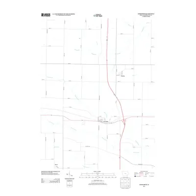
2013 Map of Ainsworth
USGS Topo · Published 2013About this map
The town of Ainsworth serves as a central hub in this agricultural region of southeast Iowa, where the intersection of modern transit and historical corridors like Old Military Rd shapes the landscape. The township is defined by a dense network of watercourses, including the meandering paths of S Fork Long Cr and N Fork Long Cr, which converge toward the east. These streams, along with Whiskey Run and Goose Cr, dictate the placement of local roads and the boundaries of farmsteads.
Find a feature on this map
49 named features on this map. Tap any name to fly to it.
Don’t see what you’re looking for? This feature index may not catch every label — zoom into the map to look around manually.
Map Details
Editions of this 2013 Ainsworth Map
This is the sole edition of this map. No revisions or reprints were ever made.
Other maps of this area

1958 · Davenport
USGS Topo · 1:250,000

1961 · Davenport
USGS Topo · 1:250,000

1962 · Davenport
USGS Topo · 1:250,000

1969 · Kalona
USGS Topo · 1:24,000
1969 · Riverside
USGS Topo · 1:24,000

1969 · Washington
USGS Topo · 1:24,000
1969 · Lone Tree
USGS Topo · 1:24,000

1970 · Cotter
USGS Topo · 1:24,000

1970 · Ainsworth
USGS Topo · 1:24,000

1980 · Wayland
USGS Topo · 1:24,000