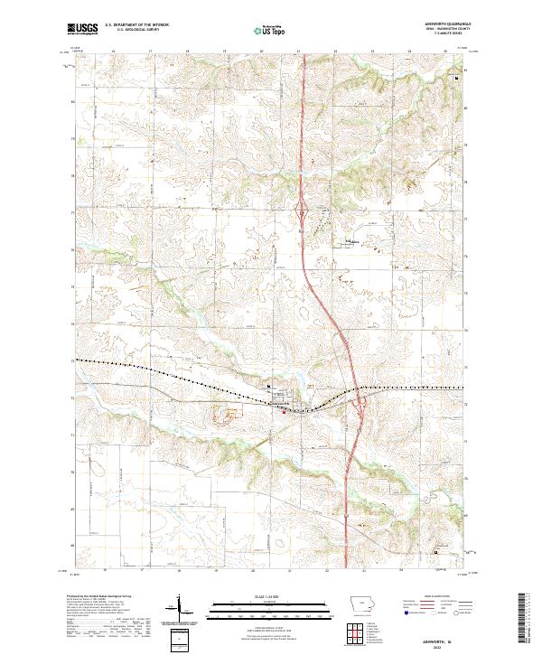
2022 Map of Ainsworth
USGS Topo · Published 2022About this map
Ainsworth serves as the primary hub of this agricultural landscape in Washington County, situated along the crossroads of Highway 92 and Highway 218. The map reveals a deeply etched drainage pattern defined by the North and South Forks of Long Creek, which wind through the township alongside Whiskey Run and Goose Creek. This modern survey by the U.S. Geological Survey preserves the legacy of early travel and settlement, noting the path of the Old White Way, a historic auto route that predated the primary highway system. Genealogists will find critical landmarks such as Ainsworth Cem, Salem Cem, and Campground Cem distributed across the sections. The inclusion of the Marr Park Trails Trail near the center of the sheet highlights the integration of recreational land use within the long-established rural grid system of eastern Iowa.
Find a feature on this map
45 named features on this map. Tap any name to fly to it.
Don’t see what you’re looking for? This feature index may not catch every label — zoom into the map to look around manually.
Map Details
Editions of this 2022 Ainsworth Map
This is the sole edition of this map. No revisions or reprints were ever made.
Other maps of this area

1958 · Davenport
USGS Topo · 1:250,000

1961 · Davenport
USGS Topo · 1:250,000

1962 · Davenport
USGS Topo · 1:250,000

1969 · Kalona
USGS Topo · 1:24,000
1969 · Riverside
USGS Topo · 1:24,000

1969 · Washington
USGS Topo · 1:24,000
1969 · Lone Tree
USGS Topo · 1:24,000

1970 · Cotter
USGS Topo · 1:24,000

1970 · Ainsworth
USGS Topo · 1:24,000

1980 · Wayland
USGS Topo · 1:24,000