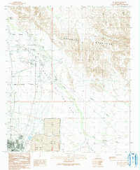
1990 Map of Ajo North
USGS Topo · Published 1991About this map
The Valley of the Ajo dominates this landscape, defined by the industrial mining operations and the presence of the Barry M Goldwater Air Force Range. To the south, the map details the residential and recreational infrastructure serving the community near Ajo, including the Ajo Country Club, a Trailer Park, and an Athletic Field. Large-scale mining is evident through the massive impoundments of the North Tailings Pond, East Tailings Pond, and South Tailings Pond, which contrast with the natural drainages of Tenmile Wash and Sikort Chuapo Wash. Small settlements like Gibson, Childs, and Childs Ranch appear alongside landmarks such as the Ajo Municipal Airport and a local Cem. The transition from the Batamote Mountains into the valley highlights a desert environment managed for both military use and mineral extraction.
Find a feature on this map
33 named features on this map. Tap any name to fly to it.
Don’t see what you’re looking for? This feature index may not catch every label — zoom into the map to look around manually.
Map Details
Editions of this 1990 Ajo North Map
This is the sole edition of this map. No revisions or reprints were ever made.
Other maps of this area

1932 · Ajo
USGS Topo · 1:62,500

1934 · Ajo
USGS Topo · 1:62,500

1953 · Ajo
USGS Topo · 1:250,000

1957 · Ajo
USGS Topo · 1:250,000

1958 · Ajo
USGS Topo · 1:250,000

1958 · Midway
USGS Topo · 1:62,500

1958 · Hat Mountain
USGS Topo · 1:62,500

1962 · Ajo
USGS Topo · 1:250,000

1963 · Ajo
USGS Topo · 1:250,000

1963 · Ajo
USGS Topo · 1:62,500