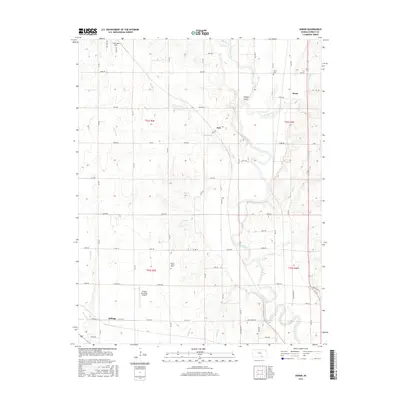
2015 Map of Akron
USGS Topo · Published 2015About this map
The Walnut River meanders southward through this portion of Cowley County, shaping the local topography and drainage patterns for tributaries like Crooked Cr and Little Dutch Cr. The landscape is defined by the historic transition from the Cherokee Strip in the north to the established farming communities further south. Small settlements like Akron and Dale are situated along the river valley, while Kellogg sits near the southwestern edge of the quadrangle. The map reveals the critical infrastructure of the mid-2010s, notably the Oxford Municipal Airport and a dense network of rural roads that connect family-named plots. Local history is anchored by the Akron Cem and Mount Vernon Cem, which serve as quiet landmarks of the region's early settlement era.
Find a feature on this map
60 named features on this map. Tap any name to fly to it.
Don’t see what you’re looking for? This feature index may not catch every label — zoom into the map to look around manually.
Map Details
Editions of this 2015 Akron Map
This is the sole edition of this map. No revisions or reprints were ever made.
Other maps of this area

1889 · Burden
USGS Topo · 1:125,000

1890 · Wellington
USGS Topo · 1:125,000

1955 · Udall
USGS Topo · 1:24,000

1955 · Mulvane
USGS Topo · 1:24,000

1955 · Wichita
USGS Topo · 1:250,000

1958 · Wichita
USGS Topo · 1:250,000

1965 · Adamsville
USGS Topo · 1:24,000

1965 · Winfield
USGS Topo · 1:24,000
1965 · Wilmot
USGS Topo · 1:24,000
1965 · New Salem
USGS Topo · 1:24,000