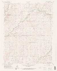
1965 Map of Wilmot
USGS Topo · Published 1966About this map
Old Indian Treaty Boundary and the Indian Treaty Boundary cut across this portion of south-central Kansas, marking a landscape defined by 19th-century land divisions and mid-20th-century resource extraction. The area is dominated by the winding course of Rock Creek and its many tributaries, including Muddy Creek, Sandford Creek, and Dutch Creek. Local industrial activity is evident in the active Oil Field and scattered oil wells that dot the terrain alongside several Gravel Pits.
Find a feature on this map
28 named features on this map. Tap any name to fly to it.
Don’t see what you’re looking for? This feature index may not catch every label — zoom into the map to look around manually.
Map Details
Editions of this 1965 Wilmot Map
2 editions found
Other maps of this area

1888 · Eldorado
USGS Topo · 1:125,000

1889 · Burden
USGS Topo · 1:125,000

1889 · Wichita
USGS Topo · 1:125,000

1890 · Wellington
USGS Topo · 1:125,000

1894 · Wichita
USGS Topo · 1:125,000

1955 · Udall
USGS Topo · 1:24,000

1955 · Douglass
USGS Topo · 1:24,000

1955 · Wichita
USGS Topo · 1:250,000

1958 · Wichita
USGS Topo · 1:250,000

1961 · Gordon
USGS Topo · 1:24,000