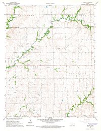
1965 Map of Wilmot
USGS Topo · Published 1966About this map
The Old Indian Treaty Boundary slices across this mid-1960s landscape, marking a historical line of demarcation through the rolling terrain of southern Kansas. At the southeastern corner, the settlement of Wilmot sits along the St Louis - San Francisco railroad, serving as a focal point for the surrounding agricultural and industrial activity. The map reveals an active Oil Field landscape, with numerous oil wells and storage tanks concentrated near Mt Tabor and the winding course of Rock Creek.
Find a feature on this map
29 named features on this map. Tap any name to fly to it.
Don’t see what you’re looking for? This feature index may not catch every label — zoom into the map to look around manually.
Map Details
Editions of this 1965 Wilmot Map
2 editions found
Other maps of this area

1888 · Eldorado
USGS Topo · 1:125,000

1889 · Burden
USGS Topo · 1:125,000

1889 · Wichita
USGS Topo · 1:125,000

1890 · Wellington
USGS Topo · 1:125,000

1894 · Wichita
USGS Topo · 1:125,000

1955 · Udall
USGS Topo · 1:24,000

1955 · Douglass
USGS Topo · 1:24,000

1955 · Wichita
USGS Topo · 1:250,000

1958 · Wichita
USGS Topo · 1:250,000

1961 · Gordon
USGS Topo · 1:24,000