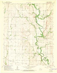
1965 Map of Akron
USGS Topo · Published 1966About this map
The Walnut River meanders through this portion of Cowley County, shaping a landscape defined by its floodplains and agricultural reaches during the mid-1960s. The small settlements of Akron and Kellogg anchor the rural infrastructure, connected by the steady presence of the Atchison Topeka and Santa Fe railroad. This era shows a clear intersection of aviation and industry, with the Oxford Airport and Richardson Landing Field serving the region alongside the Rock Southwest Oil Field and Weathered Oil Field. Genealogists and local historians can pinpoint family-linked sites such as the Akron Cem and Mt Vernon Cem, while tracing the paths of numerous tributaries like Sand Creek, Spring Creek, and Lone Elm Creek that feed into the primary river valley.
Find a feature on this map
28 named features on this map. Tap any name to fly to it.
Don’t see what you’re looking for? This feature index may not catch every label — zoom into the map to look around manually.
Map Details
Editions of this 1965 Akron Map
2 editions found
Other maps of this area

1889 · Burden
USGS Topo · 1:125,000

1890 · Wellington
USGS Topo · 1:125,000

1955 · Udall
USGS Topo · 1:24,000

1955 · Mulvane
USGS Topo · 1:24,000

1955 · Wichita
USGS Topo · 1:250,000

1958 · Wichita
USGS Topo · 1:250,000

1965 · Adamsville
USGS Topo · 1:24,000

1965 · Winfield
USGS Topo · 1:24,000
1965 · Wilmot
USGS Topo · 1:24,000
1965 · New Salem
USGS Topo · 1:24,000