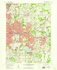
1958 Map of Akron East
USGS Topo · Published 1959About this map
Industrial expansion and aviation history converge in this eastern section of Akron, showing the city's growth into Tallmadge and Springfield townships during the late 1950s. The massive Goodyear Airdock and the adjacent Akron Municipal Airport anchor the southern landscape, reflecting the region's historical role in lighter-than-air craft and aeronautics. Nearby, the famous Derby Downs (Speedway) sits near the northern tip of Springfield Lake. Residential growth is evident in established neighborhoods like Goodyear Heights and Thomastown, while the peripheries retain larger tracts like the Goodyear Heights Metropolitan Park. The rail network, featuring the Erie RR and the Baltimore and Ohio RR, illustrates the logistical infrastructure that supported the local rubber industry. Genealogists will find numerous burial sites and small houses of worship, including the Ellet Memorial Cem and Millheim Ch, marking the older village footprints within the modernizing suburbs.
Find a feature on this map
89 named features on this map. Tap any name to fly to it.
Don’t see what you’re looking for? This feature index may not catch every label — zoom into the map to look around manually.
Map Details
Editions of this 1958 Akron East Map
This is the sole edition of this map. No revisions or reprints were ever made.
Other maps of this area

1901 · Massillon
USGS Topo · 1:62,500

1901 · Canton
USGS Topo · 1:62,500

1903 · Massillon
USGS Topo · 1:62,500

1903 · Canton
USGS Topo · 1:62,500

1903 · Akron
USGS Topo · 1:62,500

1905 · Akron
USGS Topo · 1:62,500

1906 · Kent
USGS Topo · 1:62,500

1950 · Cleveland
USGS Topo · 1:250,000

1951 · Canton
USGS Topo · 1:250,000

1953 · Canton
USGS Topo · 1:250,000