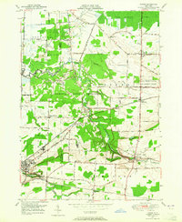
1949 Map of Akron
USGS Topo · Published 1965About this map
The Tonawanda Indian Reservation occupies the heart of this landscape, where the Tonawanda Creek meanders through dense woodland and the Tonawanda Indian Community Center. Local landmarks such as the Council House and Long House Cem underscore the cultural heritage of the area. To the south, the village of Akron is a primary hub of activity, featuring the Akron Central School and the Evergreen Cem near the banks of Murder Creek.
Find a feature on this map
59 named features on this map. Tap any name to fly to it.
Don’t see what you’re looking for? This feature index may not catch every label — zoom into the map to look around manually.
Map Details
Editions of this 1949 Akron Map
This is the sole edition of this map. No revisions or reprints were ever made.
Other maps of this area

1897 · Medina
USGS Topo · 1:62,500

1897 · Lockport
USGS Topo · 1:62,500

1899 · Niagara
USGS Topo · 1:125,000

1902 · Lockport
USGS Topo · 1:62,500

1905 · Attica
USGS Topo · 1:62,500

1905 · Depew
USGS Topo · 1:62,500

1905 · Lockport
USGS Topo · 1:62,500

1944 · Alexander
USGS Topo · 1:31,680

1948 · Depew
USGS Topo · 1:62,500

1948 · Lockport
USGS Topo · 1:62,500