
1973 Map of Akron SE
USGS Topo · Published 1976About this map
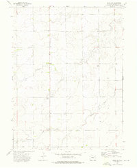
Surveyor Creek and Brunker Creek wind through the high plains of Washington County, illustrating the intricate drainage patterns of the eastern Colorado steppe during the early 1970s. This agricultural landscape is defined by its section lines and section corners, reflecting the orderly grid of the Public Land Survey System that governs much of the region's geography. To the south, the headwaters of Hell Creek emerge, further carving the rolling terrain. The map captures the quiet character of the area just after its field check in 1973, showing a network of secondary roads and section-line paths that connect the scattered farmsteads and rural holdings of this sparsely populated portion of the Great Plains.
Find a feature on this map
6 named features on this map. Tap any name to fly to it.
Don’t see what you’re looking for? This feature index may not catch every label — zoom into the map to look around manually.
Map Details
Editions of this 1973 Akron SE Map
This is the sole edition of this map. No revisions or reprints were ever made.
Other maps of this area

1954 · Limon
USGS Topo · 1:250,000

1954 · Sterling
USGS Topo · 1:250,000

1957 · Limon
USGS Topo · 1:250,000

1958 · Limon
USGS Topo · 1:250,000

1958 · Sterling
USGS Topo · 1:250,000

1972 · Otis
USGS Topo · 1:24,000

1972 · Snyder Lake
USGS Topo · 1:24,000

1973 · Akron
USGS Topo · 1:24,000

1973 · Platner
USGS Topo · 1:24,000
1973 · Akron SW
USGS Topo · 1:24,000