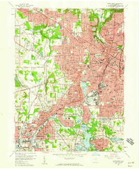
1958 Map of Akron West
USGS Topo · Published 1959About this map
Industrial and residential development defines the landscape between Akron and Barberton during the late 1950s. The presence of the Ohio and Erie Canal and the Tuscarawas River anchors the geography, while the Barberton Belt Line and major routes like the Ohio Turnpike signal the area's mid-century role as a manufacturing and transit hub. Major landmarks of the era include the University of Akron, Summit Lake, and the expanding neighborhoods of Kenmore and Maple Valley.
Find a feature on this map
152 named features on this map. Tap any name to fly to it.
Don’t see what you’re looking for? This feature index may not catch every label — zoom into the map to look around manually.
Map Details
Editions of this 1958 Akron West Map
This is the sole edition of this map. No revisions or reprints were ever made.
Other maps of this area

1901 · Massillon
USGS Topo · 1:62,500

1901 · Canton
USGS Topo · 1:62,500

1903 · Massillon
USGS Topo · 1:62,500

1903 · Canton
USGS Topo · 1:62,500

1903 · Akron
USGS Topo · 1:62,500

1905 · Akron
USGS Topo · 1:62,500

1906 · Kent
USGS Topo · 1:62,500

1950 · Cleveland
USGS Topo · 1:250,000

1951 · Canton
USGS Topo · 1:250,000

1953 · Canton
USGS Topo · 1:250,000