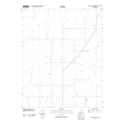
2010 Map of Alabaster Caverns
USGS Topo · Published 2010About this map
The quiet rural landscape of Woodward County is anchored by the settlement of Haskew, a community centered around the local grid of farm-to-market roads. This 2010 survey reveals a classic Oklahoma prairie layout, where section lines like n2140 RD and e0250 RD define the movement of goods and people between agricultural holdings. Significant local heritage is preserved at the Haskew Cemetery, while modern land use is represented by the Henderson Farm Airport in the southeastern quadrant, illustrating the continued importance of private aviation in managing large ranching or farming operations. The terrain is naturally drained by a network of seasonal watercourses, including Traders Creek and the curiously named Slicker Creek, which meander through the open plains. The map provides a clear look at the intersection of traditional burial sites and modern infrastructure during the early 21st century.
Find a feature on this map
20 named features on this map. Tap any name to fly to it.
Don’t see what you’re looking for? This feature index may not catch every label — zoom into the map to look around manually.
Map Details
Editions of this 2010 Alabaster Caverns Map
This is the sole edition of this map. No revisions or reprints were ever made.
Other maps of this area

1955 · Woodward
USGS Topo · 1:250,000

1958 · Woodward
USGS Topo · 1:250,000

1970 · Fairvalley SW
USGS Topo · 1:24,000

1970 · Alabaster Caverns
USGS Topo · 1:24,000

1970 · Fairvalley SE
USGS Topo · 1:24,000

1970 · Fairvalley
USGS Topo · 1:24,000

1970 · Edith
USGS Topo · 1:24,000
1970 · Freedom
USGS Topo · 1:24,000

1970 · Sleeping Bear Creek SE
USGS Topo · 1:24,000

1971 · Selman SE
USGS Topo · 1:24,000