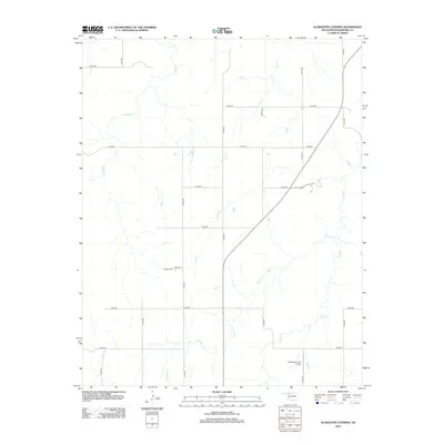
2012 Map of Alabaster Caverns
USGS Topo · Published 2012About this map
Haskew Cem is a primary landmark for genealogy and local history in this rural corner of Woodward County. The landscape is defined by its dendritic drainage patterns, with Traders Cr, Girl Cr, Slicker Cr, and Long Cr carving through the plains. The section line road system creates a distinct grid across the terrain, though it is interrupted by the modern diagonal corridor of State Highway 50. In the southeastern portion of the quadrangle, the Henderson Farm Airport represents the integration of private aviation into the local agricultural economy. This 2012 survey illustrates the modern configuration of rural Oklahoma, where large-scale farming and ranching dominate the land use, centered around family-named landmarks and watercourses.
Find a feature on this map
26 named features on this map. Tap any name to fly to it.
Don’t see what you’re looking for? This feature index may not catch every label — zoom into the map to look around manually.
Map Details
Editions of this 2012 Alabaster Caverns Map
This is the sole edition of this map. No revisions or reprints were ever made.
Other maps of this area

1955 · Woodward
USGS Topo · 1:250,000

1958 · Woodward
USGS Topo · 1:250,000

1970 · Fairvalley SW
USGS Topo · 1:24,000

1970 · Alabaster Caverns
USGS Topo · 1:24,000

1970 · Fairvalley SE
USGS Topo · 1:24,000

1970 · Fairvalley
USGS Topo · 1:24,000

1970 · Edith
USGS Topo · 1:24,000
1970 · Freedom
USGS Topo · 1:24,000

1970 · Sleeping Bear Creek SE
USGS Topo · 1:24,000

1971 · Selman SE
USGS Topo · 1:24,000