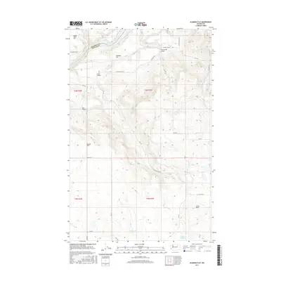
2017 Map of Alameda Flat
USGS Topo · Published 2017About this map
The Columbia River defines the northwestern boundary of this high plateau region, where the Okanogan Co and Douglas Co line crosses the water near Mah-kin Rapids. The landscape is characterized by prominent benchlands and deep incisions, notably Alameda Flat and the adjacent Saddle Horse Flat. These elevated plains are dissected by numerous drainages, including Strahl Canyon, Buck Canyon, and Twin Springs Canyon, which drop toward the river valley. To the south, the terrain shifts toward more internal drainage patterns, marked by seasonal or semi-permanent water bodies such as Rattlesnake Lake and Wilson Lake, the latter situated near the rising profile of Wilson Butte. A network of rural section-line roads, such as Alameda Flats Rd and Rex Rd, provides access to these remote reaches, reflecting the large-scale agricultural and ranching survey patterns of Eastern Washington.
Find a feature on this map
34 named features on this map. Tap any name to fly to it.
Don’t see what you’re looking for? This feature index may not catch every label — zoom into the map to look around manually.
Map Details
Editions of this 2017 Alameda Flat Map
This is the sole edition of this map. No revisions or reprints were ever made.
Other maps of this area

1950 · Boot Mtn
USGS Topo · 1:62,500

1950 · Alameda Flat
USGS Topo · 1:62,500

1952 · Alameda Flat
USGS Topo · 1:62,500

1953 · Ritzville
USGS Topo · 1:250,000

1954 · Okanogan
USGS Topo · 1:250,000

1958 · Okanogan
USGS Topo · 1:250,000

1959 · Ritzville
USGS Topo · 1:250,000

1965 · Ritzville
USGS Topo · 1:250,000

1968 · Barker Canyon
USGS Topo · 1:24,000

1968 · Foster Coulee
USGS Topo · 1:24,000